TTA has delivered the Solar PV Mapping and Development Plan for the JAMALI region, prepared for the Southeast Asia Energy Transition Partnership (ETP), hosted by UNOPS, in partnership with Indonesia’s Ministry of National Development Planning (BAPPENAS).
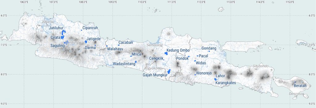
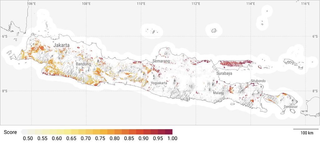
Indonesia’s solar ambitions rely on accessible data that identifies where deployment is feasible. This study combines geospatial analysis, environmental and social screening, and financial feasibility assessment to identify priority locations for utility-scale solar projects, including both ground-mounted and floating PV, to provide development pathways.
The work included:
• Solar irradiance mapping
• Grid integration assessment for the JAMALI system
• Environmental and social screening
• Financial feasibility analysis
• Assessment of regulatory and commercial barriers, including procurement processes, power purchase agreements, and permitting requirements
Key lessons from the assignment:
📍 Resource quality is only the starting point.
Once land status, protected areas, terrain, and grid proximity are considered, the number of developable sites decreases significantly. Identifying those sites is where the real value lies.
📍 A structured screening process saves time and cost.
Applying spatial and environmental screening before financial modelling ensures that detailed analysis focuses only on sites with a realistic development pathway.
📍 Clear outputs support better decisions.
Maps of technically viable areas and concise project briefs transformed a complex technical assessment into practical planning tools for decision-makers.
📍 The methodology is transferable.
This layered approach can be replicated in other regions and countries seeking to convert solar potential into an investable project pipeline.
A sincere thank you to Maryam M Karimah and Solene Gondrexon, who led this assignment, and to our consortium partners and colleagues at Southeast Asia Energy Transition Partnership, UNOPS, and Ministry of National Development Planning/Bappenas Republic of Indonesia for their collaboration throughout the project.
All reports, project briefs, and presentation materials are publicly available through ETP.
🔗 https://www.energytransitionpartnership.org/projects/1-gw-solar-mapping-and-development-plan/
Explore the interactive solar map here:
🌍https://earth.google.com/web/@-5.90660686,109.49747211,97.58492609a,1210156.19306982d,30.00040144y,9.14231393h,52.36908266t,360r/data=CgRCAggBMikKJwolCiExT1ZkcUVjNWhZZWVERWJjNnRyMXVwMFRHOFJYeUIzLXYgAToDCgEwQgIIAEoICMeMu-sBEAE?authuser=0
hashtag#TTAEnergy hashtag#SolarEnergy hashtag#EnergyTransition hashtag#GIS hashtag#RenewableEnergy hashtag#SolarPV hashtag#Indonesia hashtag#EnergyPlanning hashtag#Infrastructure hashtag#SustainableDevelopment